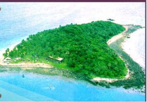
Aside from the popular Verde Island (Isla Verde) and Tingloy, there are more islands in the province that are still unknown to most Batanguenos. Here’s the list of these Batangas islands plus some important facts:
Balahibong Manok Island – Balahibong Manok or “chicken feather’ in English, is situated 2 kilometers away from Culebra or more popularly known as Bonito Island. Between these two islands is an underwater hotspring located at 20m (65 ft). It is said that when Taal volcano increases its activity, this area does also, releasing curtains of fine bubbles. A natural wonder right? You are sure to see this islet when you’re bound to the province of Mindoro Occidental or to Puerto Galera.
 Culebra Island – I was awed by the shape of this island. Yup, it’s heart-shaped. Culebra Island is located in the Eastern end of Maricaban Island (Tingloy). It has pristine white sand and crystal clear water. Culebra is also known as the Bonito Island, a popular resort in the area.
Maricaban Island – The town of Tingloy comprises most of the land area of Maricaban. Tingloy is a town island with several beach resorts and over 30 dive points that has become popular to tourists which in turn became source of its people livelihood. You can also find the Mag-Asawang Bato Peak in Tingloy.
Ligpo Island – Located in Sa Luis Batangas, this Island has one of the best diving spots in the Philippines. Corals of different types and huge gorgonians can be seen in the area.Approximately 75 feet south of the Dive 7000 Resort area and about 450 feet, lies a giant rock formation that looks like an underwater amphitheater. Originally virtually barren, the cathedral has been seeded with coral from other sites. (source here)
Sombrero Island – From afar, the island looks like a hat or sombrero. I’m sure that’s the very reason why the island is called as such. The East side of the island is ideal for swimming while the west side offers spectacular coral garden perfect for snorkeling.
Verde Island -This island seats south of Brgy. Ilijan, Batangas City and is separated from Luzon by the bodies of North Pass. It takes 45 minutes by a boat or 25 minutes by a ferry boat from Batangas City Port to reach the island. One of the famous destinations within the island is Mahabang Buhangin, a kilometer-long stretch of white sand beach. Another one is Cueva Sitio, a cave that leads to the other of the island. (Source: Wikipedia)
Macajuayan Island – The location of this island is 145 kilometers north west (300°) of the approximate center of Philippines and 107 kilometers south (189°) of the captial Manila. Have you been to this island? Share us your photos and experiences.
Bonete Island – Bonete Island is located 0.5km away from Sombrero Island. If you have visited the place, we would appreciate information about Bonete Island from you. Simply comment on this post. Thanks.
Taal Volcano Island – This volcano island is part of three municipalities of Batangas namely, Talisay, San Nicolas and Balete. Taal Volcano has been called the smallest active volcano in the world. It is located about 70-km south of Manila in the middle of a lake called Taal Lake. To know more about this island check out our team adventure in Taal last year.
Napayong Island – Just like the Taal Volcano island, Napayong can be found in Taal Lake, Tanauan City part. I have visited this island years ago but wasn’t able to keep the photos. The island could be a good venue for picnic or do boodle fight by the lake shore.
Now with all these interesting islands we have, who can say we can’t do island hopping in Batangas?
 WOWBatangas.com Your Source of Great News and Stories from the Province of Batangas, Philippines


